Washington - Pt. Roberts
Point Roberts


The border monument is on the east side of the crossing, as you exit Point Roberts and return to British Columbia. (You could have boated here, but chances are this is how you got in - there is no port of any kind.) Point Roberts is a geographical quirk of drawing a straight line boundary to define Washington. With Vancouver Island dipping well below the 49th parallel while remaining solidly Canadian, it would have been easy to negotiate the boundary around this peninsula, all the more so because the USA got a very favorable definition of the boundary between the San Juan (US) and Southern Gulf (Canada) Islands. As a fun side effect of Point Roberts' existence, ferries heading out of Tsawassen, BC for various points among the BC islands must pass through United States waters. There is a very precise delineation of juridiction. The building, the wooden curb, and all of the signs to its north are Canadian. The pavement and all signs from there south are American, resulting in the second photo's juxtaposition of an American stop sign and a Canadian no entry sign.
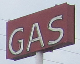
This seems perfectly ordinary, though on the cheap side. It's not ordinary. This may be the only place in one of the 50 United States where prices are expressed in USD per liter instead of per gallon. (I don't know if the various territories or protectorates may also use this practice.) Yes, all the gas stations you can drive to for some distance are in liters as well, but they're also in Canadian dollars. This almost seems to exist just for the oddness factor.


Panning from the San Juan Islands in the south to the Southern Gulf Islands and Vancouver Island in the west, in the early morning light. The Canadian Tumbo and Saturna Islands lie between Point Roberts and other points in Washington (Waldron, Stuart, and San Juan Islands, among other smaller ones).
West to Vancouver Island, BC
Back to Washington Non-Roads
Back to Non-Roads main page