Minnesota - Highway 61
Highway 61
All photos were taken heading southwest.


Panning from south to north across Wauswaugoning Bay at its namesake overlook. Hat Point leads the way, followed by Francis and Susie Islands (Little Susie and Long Islands are in front of Big Susie, but you can't really see them), then ending northeast toward Pigeon Point, the easternmost point in Minnesota.


Looking southwest before entering Grand Portage, then northeast upon entering at the other side of Hat Point and, in front, Grand Portage Island.


The sun sets in the west and Marr Island sits in Lake Superior looking south from Paradise Beach.


A progression of Red Cliff photos heading into Covill.

Either an unnamed ridge or the northern extent of the Sawtooth Mountains.
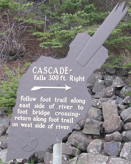


The last photo is Black Point, heading south from the falls.


Want more falls? These sorta count, south of Lutsen Mountains, but maybe only in spring.

The scene nearing Tofte.


Speaking of falls in spring, Cross River Falls is normally a lot quieter, with some trickles falling between the rocks. You can't even see the rocks in late May 2013.


Looking south near Little Marais at what I believe is faraway Shovel Point, then looking east just before entering Silver Bay at tiny unnamed islets.


Various amounts of twilight guide me from Silver Bay to Beaver Bay for the night.

A gull eclipses the moon on an eerie evening. The full photo looking east from Mariner Motel is even eerier, so I've let that close out this page.


But first, sunrise over Lake Superior.

Grand Portage State Park
Silver Bay
Split Rock Lighthouse
Gooseberry Falls
Two Harbors
Highway 61 roads photos
Back to Minnesota Non-Roads
Back to Non-Roads main page