Tennessee Roads - TN 319/Old TN 58
 and former TN 58/319


The photo atop the page is on Amnicola Hwy. EB and clearly shows no TN 58. It used to be here but was removed from the center of Chattanooga relatively recently, which is why TN 319 SB now heads east to end at the same route it multiplexed with already, TN 153. These photos start at Chattanooga State Community College and head to the far side of 153.


NB to the same inscrutable structure.

This was the south end of TN 319 in a trumpet ramp to TN 58 EB, but now it's the 319 mainline.


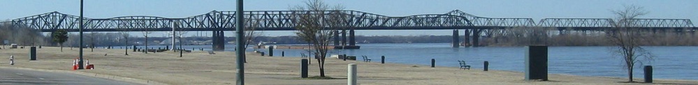
Looking west along the Tennessee River and east toward Chickamauga Dam and the 1917 Tenbridge railroad bridge. TN 153 is on the tall bridge over the dam.

SB, if you needed any further proof that TN 58 has been removed. It's now got one piece south of I-24 and the main section heading north from TN 17 at TN 153.


TN 319 has a nonexistent section of its own. These photos follow TN 319 SB as it leaves TN 153 and enters its short freeway. The stub abutment in the middle hints at a future extension around Northgate Mall and back to 319 north of 153. Right now, unusually, both routes become freeways after they split but not while together.


There seems to be enough room on the span wire for something wider than Series A.

A brown sign means something is considered a recreational destination. TN 319 SB continues straight, Soddy-Daisy is just a town, so that leaves TVA Sequoyah as the site to see. Problem: TVA Sequoyah is a nuclear power plant and they probably don't want visitors.


The northern stretch of TN 319 heads east-west along the south side of Soddy Creek, essentially an arm of Chickamauga Lake. Most of the creek is north of the road (1st photo) but based on terrain TN 319 has to bridge a few arms or feeders from the south (2nd photo).
Onto current TN 58
Onto TN 153
See more of Chattanooga
Back to Tennessee Roads
Back to Roads