New Jersey Roads - NJ State Highways - 151-170

NJ State Highways: 151-170

151   152   153   154   155   156   157   158   159   160   161   162   163   164   165   166   167   168   169   170


151

151 ran along the one-way pair of 10th St and 11th St from Wright Ave (at
I-676) east to an interchange at US 30, and then north along Flanders Ave to Federal St (CR 537). The eastbound route along 10th St and Flanders Ave was .61 miles long. Since sometime after 1969, the road has been locally maintained by Camden, and still serves traffic from I-676 north to US 30 east.

ROUTE NO. 151. Beginning on Route No. 25 (entrance road) in the vicinity of Cooper river, Camden city, New Jersey, and running thence, via the Camden business center to the Pennsylvania ferry at the foot of Market street and Federal street, Camden city. L.1946, c. 115, p. 543, s. 1.
151: [unsigned] Former Route 151 - Camden. 1953 renumbering.

Photos along the former route
End photos

152

The first incarnation of 152 was a 0.68-mile long section of road in Trenton extending along the Delaware River from
29 by the State House. At that time, 29 came into a traffic circle incorporating Lafayette St and Memorial Dr, and probably ended at Lafayette and US 206 (Warren St). 152 left the circle to the south on Peace St and followed the current path of 29 along the river. Based on the given mileage, state maintenance would have ended at Ferry St, confirmed by the 1998 SLDs. The road continued southeast, indicated as Mercer CR 649, and merged into Lamberton St. 152 does not appear on a 1952 map, but is on a 1960 map (as an unnumbered road). Sometime in the 1960s, 29 was constructed in its modern incarnation, bypassing the old circle with a complex interchange at Market St, and taking over the rest of 152 but not the southern County extension to Lamberton St.
The current 152 was legislated in 1969 as a state takeover of the bridge from Somers Point to Longport; it was numbered because of its closeness to 52. The road was taken over on 1/19/1970, and a new bridge was built in 1988 to modern standards, abandoning the old bridge to the role of a fishing pier.

ROUTE NO. ----. Beginning at or in the vicinity of the westerly abutment line of the John F. Kennedy Memorial Bridge over Risley Channel in Atlantic county and thence proceeding toward Somers Point in said county and being presently designated as Atlantic County Route No. 20. Added by L.1968, c. 397, s. 1, eff. Jan. 10, 1969.

Photos
End photos

ends at Bay Ave
Somers PointE Longport-Somers Point Rd
Egg HarborSomers Point-Longport Blvd
ends at Intracoastal Waterway


153
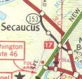
The Secaucus bypass on 3 opened on 8/1/1949, and appears to have been initially signed only as a bypass to 3 (more info is in the 3 entry). In the 1953 renumbering, the bypass became the mainline of 3, and the old route was unnumbered. It was soon numbered 153 and called Old Route 3; only the part west of Paterson Plank Road was ever state maintained, and 153 may have been truncated there at some point, but it originally ran all the way to US 1/US 9. With the construction of the Harmon Cove development in the mid-1970s, the connection to 3 at the west end was severed. NJDOT may have gotten rid of 153 then or any point thereafter until 1988 when many other routes disappeared. It was out of the Straight Line Diagrams by 1980.

Not assigned: From an intersection point of Route 3 and 8th Street, east of the Hackensack River Bridge in Secaucus, via former Route 3 and Paterson Plank Road, to and including the overpass of present Route 3 in Secaucus. 1953 renumbering.

End photos

154

41 was originally planned to bypass the center of Haddonfield (more info is in the 41 entry). In the 1953 renumbering, NJDOT decided to do away with the plans for a bypass. The section of bypass that had already been built was set off as an unnumbered route, and was soon numbered 154. In 1992 the Ellisburg Circle at the north end of 154 was rebuilt as an intersection with jughandles from 70. The two through movements are 70 and 154-41. The county-maintained part of 41 immediately to the south carries the jughandle from 70 east. A connector road was built between 41/CR 573 and 154 south of the intersection, and 41 was routed along the connector. Thus 154 now ends multiplexed with 41.

Not assigned: Section of former Route 41 from Haddonfield-Berlin Road, Delaware Township, to the intersection of Route 70 (former Route 40), in Delaware Township. 1953 renumbering

Photos
End photos

ends at Berlin Rd
Cherry HillBrace Rd
ends at Marlton Pike/Kings Hwy (41/70)


155

155 was pre-GR
S41N, Cinnaminson Ave north of US 130. It was given back to Burlington County (CR 607) sometime after 1969.

Photos along the former route

156

156 is old
US 130 through Yardville, numbered just after the GR. It may have been formed so close to the GR (in 1952) that by the time it was given a number, it was already 156 (or the GR was anticipated and thus a number was intentionally withheld).

Photos
End photos

ends at Route 130 (US 130)
HamiltonRoute 156
ends at Route 130 (US 130)


157

157 is old
US 9 in Absecon from when it ended at US 30. It was S4 pre-GR - see that page for history.

End photos

ends at E Absecon Blvd (US 30)
AbseconN Shore Rd
ends at N New Rd (US 9)


158

158 was
25AD pre-GR, probably numbered because of its proximity to 58. It was a bridge over the Passaic River between Newark and Harrison, converted from an old railroad trestle. See 25AD for history.

Photos along the former route
End photos

159

159 is old
US 46 east of Pine Brook. It was 6M pre-GR.

Photos
End photos

ends at Route 46 (US 46)
MontvilleBloomfield Ave
FairfieldBloomfield Ave, Oak Rd, Clinton Rd
ends at Route 46 (US 46)


160

160 was old
US 206 south of White Horse, formed in 1942 when 39 was slightly realigned to bypass Mission Rd. The pre-GR number is unknown. The dashed lines in the small map at left are the paths of what are now I-295 (north-south) and I-195 (east-west). The route was removed from state logs by 1980.

161

161 is a short route in Clifton. It was
S3 Spur pre-GR. It may have briefly been 61 for a short time post-GR. Not sure if that was ever posted.

Photos
End photos

ends at Allwood Rd
CliftonClifton Ave
ends at Van Houten Ave


162

162 is a bridge over the Intracoastal Waterway near Cape May, formed in 1969. It is unsigned. Its history lies in
S4C, a route proposed south from 4 (now US 9) into Cape May, but only when the state rebuilt the bridge over the Waterway was any part of the route taken over by the state and given a number.

Photos
End photos

ends at Seashore Rd
Lower TwpRelocated Seashore Rd
ends at Seashore Rd


163

163 used to lead to a bridge over the Delaware River near the town of Delaware; it now dead-ends next to a still-existing railroad bridge. Until 12/1/1953,
US 46 used the bridge, and then it was rerouted to end in Columbia and the old bridge was dismantled. More history is available on the US 46 and 6 pages. 163 is unsigned. Sometime in the 1990's, the overpass of US 46 was removed, leaving a loop ramp from the former eastbound roadway that is now the only access to the west end of 163.

Photos
End photos

ends at Route 46 (US 46)
KnowltonOld Route 46
ends at dead end


164

164 used Dowd Ave south of Newark Airport. It may have been the parallel
81 freeway, which opened 6/1982, that spelled its demise, but it appears to have disappeared from state route logs by 1969. Myles Putman says that Rand McNally maps after 1955 no longer show 164, and that the one from that year shows Dowd as Humboldt Ave., implying a deal wherein Elizabeth took over the road after construction.

Photos
End photos

165

165 is a short section of pre-GR
29 in Lambertville. It is unsigned, except as TO NORTH 29/179 and TO SOUTH 29. The history of 165 is on the 29 page. Officially, until recently, both directions of 29 ran along S Main St. But S Main St became one-way southbound for two blocks, which is why 165 northbound was signed TO NORTH 29. Recently, 29 was taken off of S Main St entirely and, after a one-block multiplex with 179, put onto 165. Thus 165 is completely multiplexed with 29.

Photos
End photos

ends at S Main St (29)
LambertvilleOld York Rd
ends at Bridge St (179)


166

166 is old
US 9 in Toms River. For a while it was also Alt. US 9. US 9 was moved onto the Garden State Parkway (444) around Toms River in 1956, when 166 was born. History of the road is in the 4 entry.

Photos
End photos

ends at Parkway Access (US 9)
BeachwoodAtlantic City Blvd
South Toms RiverAtlantic City Blvd
Toms RiverAtlantic City Blvd, Main St, Lakewood Rd
ends at Garden State Pkwy (US 9/444)


167

167 is old
US 9 at the Mullica River (bypassed 8/28/1954 by the Garden State Parkway when the main bridge was removed). The northern approach road was closed by 1984 due to one of the wooden bridges burning, and then several other bridges were destroyed or removed so that there are abandoned and inaccessible sections in the middle. Additionally, part of the Port Republic section has been closed since 1987. 167 is unsigned. The abandoned sections are no longer part of 167 [Jonathan Sachs noted this in the SLDs], and the northern part of 167 was briefly left out of the Straight Line Diagrams as well. There is 1.99 miles betweeen the two sections, reflected in milepost numbering.

Photos
End photos

ends at New York Rd (US 9)
Port RepublicRoute 167
dead-ends near Mullica River
dead-ends
Bass RiverRoute 167
ends at New York Rd (US 9)


168

168 is old
42 into Camden, ever since the new freeway was built in 1959. History of the road is on the 42 page.

Photos
End photos

ends at North-South Fwy (42)
WashingtonBlack Horse Pike
GloucesterBlack Horse Pike
RunnemedeBlack Horse Pike
BellmawrBlack Horse Pike
Mount EphraimBlack Horse Pike
HaddonBlack Horse Pike
CamdenBlack Horse Pike, Mount Ephraim Ave
ends at Ferry Ave


169

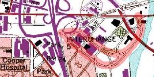
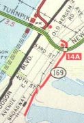
169 was built to fill the gap of the never-completed
1, later 440, in Bayonne. 169 was initially built as shown in the map at left, with the first section opening in 1959. Then it was connected in the north to 440, which was built one interchange further south than in the map at right for that purpose (it would never make it any closer to the Bayonne Bridge than that). 440 used half of a trumpet at that point to connect to the east-west section of 169, paralleling I-78 immediately to the north. In 1992, 169 was finished south to the Bayonne Bridge, and still later, 440 was realigned to remove the trumpet, replacing it with an S curve. Further history of the road is in the 1 entry. In 2001, 169 was renumbered to part of 440, with signs changed starting on 5/8/2001 [Jonathan Sachs].

ROUTE NO. . Beginning at Garfield avenue in Jersey City, Hudson county and connecting with a service road constructed by the New Jersey Turnpike Authority; and from thence proceeding eastwardly to Point Breeze; thence southerly approximately paralleling Avenue E over new location to a point opposite East 30th street in the city of Bayonne, Hudson county at location known as Constable Hook. L.1957, c. 88, p. 171, s. 1.

ROUTE NO. ----. Beginning at a point in existing Route 169 at Garfield street in Jersey City and extending thence in a general westerly direction between the Pennsylvania Railroad and the New Jersey Turnpike to a point in Route 440 Freeway approximately 1,500 feet south of the New Jersey Turnpike. Added by L.1967, c. 163, s. 1, eff. July 25, 1967.

ROUTE NO. ----. Beginning at the Bayonne bridge approach in the city of Bayonne, Hudson county and proceeding northeasterly and northerly to the vicinity of the New Jersey Turnpike, Newark Bay extension (I-78) in Jersey City, Hudson county and, thence, west-northwesterly, to the vicinity of New Jersey Route 440 in Jersey City, Hudson county. L.1976, c. 52, s. 1, eff. July 22, 1976.

Historical photos
End photos

170

In 1957,
US 206 was built around Columbus; the old route became 170. At some point after 1960, it was given to Burlington County and numbered CR 690. It was in the Straight Line Diagrams until 1985, so it may have been part of the 1988 decommissioning. History of the road is in the 39 entry.

End photos

Back to NJ State Routes main page
Back to the NJ Route Log main page
Back to NJ Roads
Back to Roads