| enters PA | |
| Frenchtown | Bridge St, Race St, Kingwood Ave |
| Kingwood | Route 12 |
| Franklin | Route 12 |
| Delaware | Route 12 |
| Raritan | Route 12 |
| Flemington | Parker Ave |
| ends at Flemington Circle (31/US 202) | |
| ends at Hollywood Blvd/Rue Lido | |
| Point Pleasant | Bridge Ave |
| Bay Head | Bridge Ave |
| continues as Bridge Ave (CR 632) | |
| ends at E McFarlan St (US 46) | |
| Dover | N Bergen St, E Clinton St, W Clinton St |
| Rockaway | W Clinton St |
| Wharton | Route 15 |
| Rockaway | Route 15 |
| Jefferson | Route 15 |
| Sparta | Route 15, Lafayette Rd |
| Lafayette | Route 15 |
| Frankford | Route 15 |
| ends at Route 206 (US 206)/Ross Corner-Sussex Rd (CR 565) | |
| ends at Belleville Tpk (7) | |
| North Arlington | Ridge Rd |
| Lyndhurst | Ridge Rd, Rutherford Ave, Route 17 |
| Rutherford | Route 17, Meadow Rd, Route 17 |
| East Rutherford | Route 17 |
| Carlstadt | 11th St |
| Wood-Ridge | Route 17 |
| Hasbrouck Heights | Route 17 |
| Hackensack | Route 17 |
| Lodi | Route 17 |
| Rochelle Park | Route 17 |
| Paramus | Route 17 |
| Ridgewood | Route 17 |
| Ho Ho Kus | Route 17 |
| Waldwick | Route 17 |
| Saddle River | Route 17 |
| Allendale | Route 17 |
| Upper Saddle River | Route 17 |
| Ramsey | Route 17 |
| Upper Saddle River | Route 17 |
| Ramsey | Route 17 |
| Mahwah | Route 17, I-287 |
| enters New York (I-287/17) | |
| section | location | date | what it was previously |
| (35F) 1A/2A | 138 to 33 | 1967 | new |
| (35F) 2B/3A | 33 to Deal Rd | 1969 | new |
| (18) 3B | Deal Rd to 36 | 6-21-1988 | new |
| (18F) 3C/2E | 36 to Wayside Rd | new | |
| (18) 10E | Wayside Rd to Obre Rd | 1978 | new |
| (18F) 10B | Obre Rd to Normandy Rd | 1977 | new |
| (18F) 9B/10A | Normandy Rd to 79 | 1974 | new |
| (18F) 8A/9A | 79 to US 9 | 1974 | new |
| (18) 5 | US 9 to Spring Valley Rd | 1960 | new |
| (18) 4 | Spring Valley Rd to Ferry Rd | 1959 | new |
| (18) 3 | Ferry Rd to 516/527 | 1959 | new |
| (S-28) 2A | 516/527 to Rues Ln | 1932 | new |
| (S-28) 2 | Rues Ln to 535 | 1932 | new |
| (S-28) 1 | 535 to 527 | 1932 | new |
| (S-28) 1A | 527 to US 1 | 1932 | Old Bridge Turnpike |
| (S-28) 3 | US 1 to New St | 1933 | Old Bridge Turnpike |
| (18) 11A/7B | New St to 27 | 1979 | Old Bridge Turnpike |
| (18) 11F | 27 to Huntington St | 1983 | new |
| (18) 11E | Huntington St to River Rd | 1980 | new |
| ends at Route 138 (138) | |
| Wall | Route 18 |
| Neptune | Route 18 |
| Ocean | Route 18 |
| Eatontown | Route 18 |
| Tinton Falls | Route 18 |
| Colts Neck | Route 18 |
| Freehold | Route 18 |
| Marlboro | Route 18 |
| Old Bridge | Route 18 |
| East Brunswick | Route 18 |
| New Brunswick | Route 18, Burnet St, Memorial Pkwy, Route 18 |
| Piscataway | Route 18, Hoes Ln, Centennial Ave |
| ends at I-287 | |
| ends at Route 18 (18) | |
| Piscataway | Possumtown Rd |
| ends at I-287 | |
| ends at Route 46 (US 46) | |
| Clifton | Broad St, Route 19 |
| Paterson | Route 19, Ward St |
| ends at Main St | |
| ends at Route 46 (US 46) | |
| Paterson | McLean Blvd, [McLean Blvd, 1st Ave](2nd Ave, River St) |
| ends at Lincoln Ave | |
| section | location | date |
| 1/1A | US 1/US 9/US 22 to Poinier St | 1934 |
| 2 | Poinier St to Market St | 1934 |
| 3 | Market St to Center St | 1936 |
| 4A | Center St to Clay St | 1936 |
| 5 | Chester Ave to 7 | 1931 |
| 4C/4D/4E/5A | Clay St? to Chester Ave | 1955 |
| Chester Ave to 7 | after 1960 | |
| 1A | 7 to Belleville/Nutley line | 1958 |
| 1B | Belleville/Nutley line to Park Ave | 1959 |
| 1C | Park Ave to Clifton/Passaic line | 1961 |
| 4A | Clifton/Passaic line to Paulison Ave | 1970 |
| 4C | Paulison Ave to Market St | 1974 |
| ends at Route 1/Route 22 (US 1/US 9/US 22) | |
| Newark | McCarter Hwy, Route 21 |
| Belleville | Route 21 |
| Nutley | Route 21 |
| Clifton | Route 21 |
| Passaic | Route 21 |
| Wallington | Route 21 |
| Passaic | Route 21 |
| Clifton | Route 21 |
| ends at Route 46 (US 46) | |
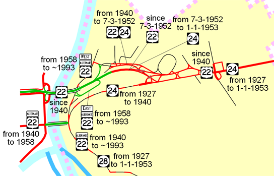 US 22 runs east-west across the northern part of the state. US 22 was signed in 1927. The route came into New Jersey from Pennsylvania on the free bridge in Phillipsburg. It turned south on S Main St and followed that to the beginning of state maintenance, from which it took 28 (pre-1927 9) to Elizabeth. In Elizabeth, US 22 followed 27-28 LINK (which was also pre-1927 9) to the end at 27 (which was US 1/US 9 until 1931).
| enters Pennsylvania | |
| Phillipsburg | Route 22, Memorial Pkwy |
| Lopatcong | Route 22 |
| Greenwich | Route 22 |
| Pohatcong | Route 22 |
| Greenwich | Route 22 |
| Pohatcong | Route 22, ramp |
| Greenwich | ramp, I-78 |
| Bloomsbury | I-78 |
| Bethlehem | I-78 |
| Union Twp | I-78 |
| Franklin | I-78 |
| Clinton Borough | I-78 |
| Clinton Twp | I-78, Route 22 |
| Lebanon | Route 22 |
| Clinton Twp | Route 22 |
| Readington | Route 22 |
| Branchburg | Route 22 |
| Bridgewater | Route 22 |
| Bound Brook | Route 22 |
| Bridgewater | Route 22 |
| Green Brook | Route 22 |
| North Plainfield | Route 22 |
| Watchung | Route 22 |
| Scotch Plains | Route 22 |
| Mountainside | Route 22 |
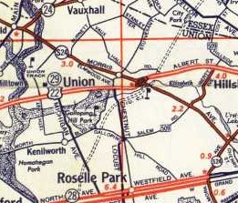
| Springfield | Route 22 |
| Union | Route 22 |
| Hillside | Route 22 |
| Newark | Route 22 |
| ends at Route 1/McCarter Hwy (US 1/US 9/21) | |
| ends at Bloomfield Ave | |
| Verona | Pompton Ave |
| Cedar Grove | Pompton Ave |
| Little Falls | Pompton Ave |
| Wayne | Route 23 |
| Pequannock | Boulevard |
| Riverdale | Route 23 |
| Kinnelon | Route 23 |
| Butler | Route 23 |
| Kinnelon | Route 23 |
| West Milford | Route 23 |
| [Kinnelon](West Milford) | Route 23 |
| West Milford | Route 23 |
| Jefferson | Route 23 |
| [West Milford](Jefferson) | Route 23 |
| Jefferson | Route 23 |
| West Milford | Route 23 |
| Jefferson | Route 23 |
| West Milford | Route 23 |
| Jefferson | Route 23 |
| Hardyston | Route 23 |
| Franklin | Route 23 |
| Hamburg | Hamburg Tpk |
| Hardyston | Route 23 |
| Wantage | Route 23 |
| Sussex | Hamburg Ave, Loomis Ave, Mill St, Bank St, Clove Ave |
| Wantage | Route 23 |
| Montague | Route 23 |
| enters New York (Orange CR 15) | |
| section | location | date | what it was previously |
| (12) 3 | Phillipsburg line to Greenwich/Franklin line | 12/15/1919 | Washington Turnpike |
| (12) 4 | Greenwich/Franklin line to Franklin/Washington line | 12/15/1919 | Washington Turnpike |
| (12) 5 | Franklin/Washington line to Port Colden | 12/15/1919 | Washington Turnpike |
| (12) 6 | Port Colden to Stephensburg | 1/15/1920 | Washington Turnpike west of Penwell Rd |
| (12) 7 | Stephensburg to Hackettstown | 1/15/1920 | Washington Turnpike spur east of 517 |
| section | location | date |
| 9E/10H | I-287 to Florham Park/Madison line | 11/17/1992 |
| 10F/11J | Florham Park/Madison line to Triborough Rd | 11/17/1992 |
| 11D | Triborough Rd to JFK Pkwy | 11/17/1992 |
| 11C/12H | JFK Pkwy to 527 | 1974 |
| 12C | 527 to I-78 | 1974 |
| ends at Route 57 (57/182) | |
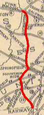
| Hackettstown | Mountain Ave |
| Washington | Schooleys Mountain Rd, E Mill Rd |
| Chester Twp | Washington Tpk |
| Chester Borough | W Main St, E Main St |
| Chester Twp | Washington Tpk |
| Mendham Twp | Washington Tpk |
| Mendham Borough | W Main St, E Main St |
| Mendham Twp | E Main St |
| Morris Twp | Mendham Ave |
| Morristown | Washington St, [South St](N Park Pl, E Park Pl, Mendham Ave) |
| ends at South St (US 202/124) | |
| ends at I-287 (I-287) | |
| Hanover | Route 24 |
| Morris Twp | Route 24 |
| Hanover | Route 24 |
| Florham Park | Route 24 |
| Madison | Route 24 |
| Florham Park | Route 24 |
| Chatham | Route 24 |
| Millburn | Route 24 |
| Summit | Route 24 |
| [Summit](Millburn) | Route 24 |
| Summit | Route 24 |
| Millburn | Route 24 |
| [Summit](Millburn) | Route 24 |
| Millburn | Route 24 |
| Summit | Route 24 |
| Springfield | Route 24 |
| ends at I-78 (I-78) | |