New Jersey Roads - NJ State Highways - 1-4

NJ State Highways: 1-4

US 1   Alt. US 1   Bus. US 1   US 1-9 Truck   1   S1   S1A   2   2N   3   S3   S3 Spur   4   4A   4N   4 Parkway   S4   S4A   S4B   S4C   S4D

US 1

US 1 runs from Pennsylvania near Trenton to New York City (on the George Washington Bridge). Before the GR, it was
26 from PA to current 26 south of New Brunswick, S26 from there to US 130 (old 25), 25 from there to Tonnele Circle in Jersey City, 1 to I-95, and 4/6 to the NY state line on the George Washington Bridge.
US 1 was marked in 1927. The path in New Jersey ran from the Pennsylvania line in Trenton to the New York line in Jersey City. In Trenton, it presumably used Bridge St, Warren St, and Brunswick Ave. It probably didn't use the Calhoun St Bridge in Trenton, as the Lincoln Highway did, because that bridge had a weight limit, but a 1941 map takes US 1 over the Calhoun St Bridge into Trenton, and down Calhoun St to Princeton Ave, where it rejoins what would otherwise be the old alignment. 1934 and 1952 maps both take it on the above described "presumable" alignment. At the Trenton city line (Spruce St) the road became state maintained. Until 1927 this was 13; in 1927 it became 27. From Trenton, US 1 used 27 (former 13) to Newark; the section from New Brunswick to Newark was 1 until 1927. History of this section is in the 27 entry. From Newark east to Jersey City and the Hudson River, US 1 was 1 before the 1927 renumbering. In 1927, 25 was assigned to this route, including the under-construction tunnel to Manhattan. It seems the tunnel approach east of Tonnele Circle was not done yet when US 1 shields were posted, and neither was 25 around downtown Newark; my best guess is that US 1 originally followed the Lincoln Highway east from Newark (NYC area inset). It appears that this route used Passaic Ave to reach the bridge over the Passaic River on 25 (Jimmy and Sharon Williams' 1927 map shows how pre-1927 1 was probably signed through Newark). From there it ran east on 25 and Communipaw Ave to Hudson Blvd, which it took north to Union City. From there either 48th St or 49th St led east to Pershing Rd, which went down the Palisades to the ferry to New York.
When the Holland Tunnel and approach from Tonnele Circle opened on 11/13/1927, US 1 then ran through it. The first section of what was known as the Pulaski Skyway (now the elevated Newark freeway), 25 from the Newark Airport north to the east edge of Newark, opened in 1928. It's not clear if US 1 was rerouted onto it at that time, or if NJDOT waited until the rest of 25 in and south of Newark was finished. 26 was completed from Trenton to New Brunswick in 1930, causing US 1 to be rerouted onto it from Brunswick Circle to downtown New Brunswick. In 1931, the last sections of 25 and S26 between south of New Brunswick and Newark were completed, and US 1 was routed off the old road from south of New Brunswick to Newark. Current US 1 from the Trenton area to Newark, at the south end of the Pulaski Skyway (including the original Skyway, which is now US 1 southbound north of Newark Airport), was built from 1928 to 1931 as 25. Before this, US 1 (possibly signed TEMPORARY) used US 206 and 27 (once both 27) from Trenton to Newark. In Newark it went north on Broad St to downtown, and probably east on Market St and Raymond Blvd, or maybe Market St and Ferry St, to the current junction of US 1/US 9 and US 1-9 Truck.
On 9/1/1932, the Pulaski Skyway opened from Newark to Tonnele Circle, originally as 25 Link but soon becoming a realignment of 25. US 1 may or may not have been routed onto it originally; a 1934 map keeps it on the old alignment, but definitely by 1941 it was on the Skyway. This may have coincided with the redesignation of the Skyway and/or the truck ban. Before the Skyway was built, US 1 had gone over the Passaic and Hackensack Rivers on US 1-9 Truck (and 25T/1) into Jersey City. By the end of 1934 [NYT 12/16/1934], US 1 was rerouted to go over the recently-opened George Washington Bridge via 1 and 4/6 north from Tonnele Circle. The old route of US 1 to the Holland Tunnel became Bus. US 1. This was probably done when the bridge approach from the south (1/6) was finished.
The freeway in Trenton, south of Bus. US 1 at Brunswick Circle, opened in 1952-53; it was built as an extension to 26. US 1 was then rerouted from the former alignment, which went over the Free Bridge (Trenton Makes Bridge) onto Bridge St (which has been partly cut off and realigned by the new freeway), Warren St (which used to go directly south from Lafayette St, and has been cut off by the Capitol Complex), Princeton Ave (which is now US 206 southbound), and the cutoff route to the Brunswick Circle, where it joined the later alignment, which is now Bus. US 1. The freeway in Trenton was built north of Bus. US 1 in 1955; it wasn't completed back to US 1 (and thus opened to traffic) until 1973 though. Between 1973 and 1988, it was numbered 174, until US 1 was moved onto it and old US 1 was renumbered as Bus. US 1. It's not clear when, but at some point (after 1960) a one-way pair was instituted in Trenton, with northbound Alt. US 1 cutting over on Livingston St to Broad St and then up Brunswick Ave to Brunswick Circle, and southbound splitting from the circle onto Brunswick Circle Extension and down Princeton Ave into Warren St. Warren St was also moved to the east south of downtown, maybe at the same time.

U. S. 1: From Lower Bridge (Bridge Street Bridge) Trenton, via local streets to intersection of Routes U. S. 206 (former Route 27) and U. S. 1 (former Route 26) in Lawrence Township, via former Route 26 and former Route S26 to junction of Route U. S. 130 (former Route 25) to junction Route U. S. 9 (former Route 35) at Woodbridge, and via former Route 25 through Elizabeth to Newark, via Pulaski Skyway to junction with former Route 1 (Tonnelle Avenue, Jersey City), via former Route 1 to junction with Route U. S. 46 (former Route 6) at Ridgefield, via Route U. S. 46 (former Route 6) to George Washington Bridge. Note - On completion of Trenton Freeway, Route U. S. 1 will run from Delaware River Toll Bridge, Trenton, via Freeway to junction with Route U. S. 1 (former Route 26). Route U. S. 1 Alternate will run from Delaware River Free Bridge, Trenton, via city streets to junction with Freeway and former Route 26. 1953 renumbering

Photos
End photos
History (Trenton) (Steve Anderson)
History (Pulaski Skyway) (Steve Anderson)
History (George Washington Bridge) (Steve Anderson)

enters Pennsylvania (US 1)
TrentonTrenton Fwy
LawrenceTrenton Fwy, Brunswick Pike
West WindsorBrunswick Pike
PlainsboroBrunswick Pike
South BrunswickRoute 1
North BrunswickRoute 1
New BrunswickRoute 1
EdisonRoute 1
WoodbridgeRoute 1
RahwayRoute 1
LindenEdgar St, Carlton St
ElizabethCarlton St, Route 1, Spring St
NewarkMcCarter Hwy, Pulaski Skyway
KearnyPulaski Skyway
Jersey CityPulaski Skyway, Tonnelle Ave
North BergenTonnelle Ave
FairviewBroad Ave
RidgefieldBroad Ave
Palisades ParkBroad Ave, Route 46, Bergen Blvd
Fort LeeBergen Blvd, Route 46, George Washington Bridge
enters New York (US 1/US 9/I-95)


Alternate US 1

Alt. US 1, formed in 1953, ran from the Pennsylvania line through Trenton to the Brunswick Circle at US 1 (now Bus. US 1) on the old route of US 1; the path was Bridge St, New Warren St, S Warren St, [Livingston St, S Broad St, N Broad St, Brunswick Ave](S Warren St, N Warren St, Princeton Ave, Brunswick Circle Ext). Alt. US 1 died in 1988, but for a while, it was still (unofficially) signed as an extension of Bus. US 1; instead of running south from Brunswick Circle to US 1, Bus. US 1 is spottily signed through downtown Trenton to Pennsylvania in an attempt to replace that route, while the short section of Bus. US 1 between the circle and US 1 is signed TO US 1 SOUTH. This route was likely 27 pre-GR. The last ALT shield stood in Trenton where US 206 SB jogs left, I believe removed in late 2005.

Photos
End photos

Business US 1

Business US 1 is old
US 1 in northeastern Trenton. Signage (apparently installed by NJDOT [Ray Martin]) disagrees with the official route; instead of rejoining US 1 at Brunswick Circle, it instead continues on the old route of US 1, and later former Alt. US 1, through downtown Trenton into Pennsylvania, where it becomes PA 2060 and PA 32 (not signed Business US 1 for many years). This extension is shown in white on the log below, and the official route is bold-italic where it disagrees with signage. The bold-italic part is signed TO US 1 SOUTH in Brunswick Circle. On 1/1/1988, the final section of the Trenton Freeway was renumbered from 174 to US 1, and the old route of US 1 via Brunswick Circle became Bus. US 1.
From NJDOT: "The section south of the Brunswick Circle, known as Brunswick Circle Extension-Princeton Avenue-Martin Luther King, Jr. Boulevard, to the vicinity of Calhoun Street in the Townships of Lawrence and Ewing, and the City of Trenton is under Mercer County jurisdiction. Hence the section to the south within Trenton known as Martin Luther King, Jr. Boulevard is under municipal jurisdiction. As a service to the public, the Department of Transportation has provided signing as depicted in the photo you provided."
In addition, 139 was once Bus. US 1 (and Bus. US 9), but the number was changed sometime after NY 1A was dropped along with most other routes in Manhattan, possibly as late as 1988 (the creation of the other Bus. US 1 in Trenton). One US 1 shield remains eastbound from an EAST BUSINESS 1 9 assembly. 139 is pre-mid 1930's US 1/US 9, which took the Holland Tunnel to NYC. This was also 25 pre-GR.

U. S. 1 Business: From junction of Route U. S. 1 at Tonnelle Avenue, Jersey City, via former Route 25 to Jersey Avenue, Jersey City (Holland Tunnel Plaza). 1953 renumbering.

End photos

enters Pennsylvania (PA 2060)
TrentonBridge St, New Warren St, S Warren St, [Livingston St, S Broad St, N Broad St, Brunswick Ave](S Warren St, N Warren St, Princeton Ave)
Lawrence[Brunswick Ave](Princeton Ave, Brunswick Circle Ext)
ends at Trenton Fwy (US 1)
LawrenceStrawberry St, Brunswick Pike
ends at Trenton Fwy (US 1)
In the log above, the signed route is in italics and the official route is in bold underline where they disagree with each other.

US 1 Truck (and US 9 Truck)

US 1 Truck is old US 1/US 9 in the Newark-Jersey City area, since trucks are not allowed on the Pulaski Skyway. It is completely cosigned with US 9 Truck. It came into existence on or after 9/1/1932, when the Pulaski Skyway opened. It was given the number 25T on the east-west portion (west of current 440); the north-south portion had always been part of 1.

U. S. 1 Truck: From junction of Route U. S. 1 at west end of Pulaski Skyway, via former Route 25 (Communipaw Avenue) to former Route 1, and via former Route 1 to junction with Route U. S. 1 at Tonnelle Avenue, Jersey City. 1953 renumbering

Photos
End photos

ends at Pulaski Skyway (US 1/US 9)
NewarkLincoln Hwy
KearnyLincoln Hwy
Jersey CityLincoln Hwy, US 1-9 Truck
ends at Tonnele Circle (US 1/US 9/139)


1

When 1 was defined in 1927, it pretty much followed the route of what is now
501 from Bayonne to the New York state line, although just about none of the route was state maintained. When the state routes were amended in 1929, 1 was moved east to the already-existing state-maintained 18N. The part of 18N south of where 1 would leave it in Fort Lee became S1A; this was probably signed (along with part of 5) as a temporary route of 1 until 1 was finished through Fort Lee in 1933. Once the Bayonne Bridge opened, 1 ran from there (Staten Island) north along the Bayonne peninsula to Fort Lee, and then north along the Hudson River back to New York State. In the GR it was renumbered to 440 south of Communipaw Ave in Jersey City (which was originally 25, later 25T), US 1-9 Truck from there to the Tonnele Circle, US 1/US 9 from there to Fort Lee, and US 9W from there to New York.
Traffic was routed along Hudson Blvd between the Bayonne Bridge and 63rd St until the route through Bayonne could be built. A 1931 New York Times article says that "construction of Route 1 from Jersey City to Bayonne as a new artery to the Bayonne-Staten Island Bridge might be indefinitely deferred... unless the Bayonne officials cooperated in providing rights of way" [NYT 10/7/1931, p. 32]. The plan for 1, and later 440, would have taken the road on landfill in the Passaic River on the west shore of Bayonne. This was never built, but a road along the east side of Bayonne was built as 169. In 2001, 169 was renumbered to part of 440, finally completing the route to the Bayonne Bridge. 169 signs were changed to 440 starting on 5/8/2001 [Jonathan Sachs].
The Bayonne Bridge opened on 10/15/1931. The section of 1 from the Bayonne-Jersey City line to Communipaw Ave (US 1-9 Truck) opened in 1935-36 (the final bit to former 169 opened in 1971). North of the Tonnele Circle, 1 opened in 1928-32. The short section bypassing downtown Fort Lee didn't open until after 1934; this resulted in a short extension of S1A (now 67). A realignment was proposed to the west from a bit north of the Tonnele Circle to Shaler Blvd in Ridgefield. When the Palisades Interstate Parkway was finished through Alpine in 1957, the northbound route of what was by then just US 9W near the state line was cut, and the southbound alignment became two-way.

ROUTE No. 18--NORTH (1917). FORT LEE TO NEW YORK STATE LINE, via Englewood Cliffs and Alpine.
ROUTE No. 1. NEW YORK STATE LINE AT ROCKLEIGH TO BAYONNE, via Rockleigh, Alpine and Cresskill, Englewood, Fort Lee, Palisades Park and Ridgefield, Township of North Bergen in Hudson County, Jersey City and Bayonne. L. 1927, c. 319.
ROUTE NO. 1. Alpine to Bayonne. Beginning at the New York state line on state highway route heretofore designated as Route No. 18--north in Alpine and terminating in Bayonne, by way of Alpine, Tenafly, Fort Lee and Ridgefield, in Bergen county, North Bergen, Jersey City and Bayonne, in Hudson county. L. 1929, c. 126, p. 215, s. 1.
Left: NJ 1 and NJ S1 in 1927.

End photos

sectionlocationdatewhat it was previously
Bayonne Bridge10/15/1931new
9BHudson Blvd at 63rd St to Danforth Ave1936new
8Danforth Ave to Communipaw Ave11/1934new (along Morris Canal ROW)
3/4/5Communipaw Ave to Tonnele Circle1930?
1Tonnele Circle to Secaucus Rd1928
2Secaucus Rd to Bergen Tpk1930
takeoverBergen Tpk to Hudson/Bergen county line1945Bergen Turnpike
takeoverHudson/Bergen county line to Edgewater Ave1939Bergen Turnpike
(10) ?Edgewater Ave to 51920
(1/4/6) 1/25 to Central Blvd1931new north of Broad Ave
(1/4/6) 3Central Blvd to Fort Lee Rd1931new
(1/4/6) 6Fort Lee Rd to 41933new
64 to 671932new
767 to Palisades Ave1932
(18-N) 5Palisades Ave to Hillside Ave1928
(18-N) 1Hillside Ave to PIP Exit 31925
(18-N) 2PIP Exit 3 to state line1927


S1

S1 was built to help feed traffic into the George Washington Bridge; it connected the Hudson County boulevard (presumably what is now Kennedy Blvd.) to the bridge. In the 1953 renumbering it became
63.

ROUTE No. S-1. In southerly direction through Ridgefield and Fairview connecting with Hudson County West Boulevard in North Bergen. L. 1927, c. 319.
ROUTE NO. S-1. A spur from Route No. 1 in the vicinity of Fort Lee, running in a southerly direction through Ridgefield and Fairview, connecting with the Hudson county boulevard in North Bergen. L. 1929, c. 126, p. 215, s. 1.

sectionlocationdate
2Hudson Blvd to 51931
15 to US 461932


S1A

S1A was formed in 1929 from the part of
18N that did not become 1. It appears to have all been taken over by the state in 1927. In 1953 it was renumbered to 67. The only change before the GR was a slight increase in length when 1 was finished in Fort Lee.

ROUTE NO. S-1-A. Beginning on Route No. 1 in the vicinity of Fort Lee and running in a southerly direction through Fort Lee on Lemoine and Palisade avenues and connecting with state highway Route No. 5. L. 1929, c. 126, p. 215, s. 1.

2

2 is the old number of
17. It was renumbered to 17 in March of 1942 (NY Times, 3/20/42) to match NY 17. 17N was legally defined in 1923 to go from Newark to the New York state line at Suffern. If it was ever signed to Newark, it used the Newark Turnpike to Harrison, and then went north on 4th St and Kearny Ave, but it's very possible that it always began where it does now. At the Hudson/Bergen county line, state maintenance began, and 17N used Park Ave into Rutherford. There it headed north on Hackensack St, which becomes Terrace Ave and leads to Hackensack. 17N originally turned onto Essex St and headed northwest on Passaic St to Paramus Rd, and then was realigned to bypass downtown Hackensack. It then used the old Franklin Turnpike to the state line. Maps suggest that 17 originally detoured through Ridgewood on Ridgewood Ave and Maple Ave, perhaps to serve Ridgewood instead of bypassing it. In 1927, 2 was defined as a replacement for 17N, except that its southern end was at 7. By then, New York had numbered its state routes, and the continuation in New York was NY 17.
Gradually, each section north of Rutherford was bypassed, with the first bypass, from Meadow Rd in Rutherford north to Terrace Ave south of Hackensack, being built at the same time as the road to the south was taken over (if the confusing information in the SLD is correct). The only portion of old road north of Hackensack to be reused was the bridge and approaches over the Saddle River in Paramus and Ridgewood. 2 used to leave the current 17 alignment in Hasbrouck Heights at Polify Rd. It then went north on Polifly Rd and 1st St and west on Passaic St, which curves to the north into Paramus Rd. 2 then went north to Franklin Tpk (at the location of present day 17), which it took northwest and north to the state line at Mahwah; most of Franklin Tpk is now CR 507. This section was bypassed between 1933 and 1936.

ROUTE No. 2. NEW YORK STATE LINE NEAR SUFFERN TO NORTH ARLINGTON, via vicinity of Ridgewood, Hackensack, Hasbrouck Heights, Rutherford, Lyndhurst, terminating at Route No. 7 in Borough of North Arlington. L. 1927, c. 319.
ROUTE NO. 2. Hohokus township to North Arlington. Beginning in the state boundary line between New York and New Jersey at a point near Suffern, New York, passing through the vicinity of Ridgewood, Hasbrouck Heights, Rutherford, Lyndhurst and North Arlington, and terminating on Route No. 7 in the borough of North Arlington. L. 1929, c. 126, p. 215, s. 2.
Left: NJ 2 in 1927.

sectionlocationdatewhat it was previously
(17-N) takeover?7 to Polifly Rd1927?
6Polifly Rd to 41933new
74 to Paramus Rd1934new
7A/8AParamus Rd to Franklin Tpk, Ramsey1936Franklin Turnpike north .35 miles from Paramus Rd, new elsewhere
9Franklin Tpk, Ramsey to New York state line1933new


2N

2N went west from
17 in Kingsland across the Passaic River and across 7, ending at Union Ave. It was assigned in 1938; it is unclear when it died.

ROUTE NO. 2-N. Beginning at Route No. 2 in the township of Lyndhurst, Bergen county and running westerly along Kingsland avenue and along Park avenue in the town of Nutley, Essex county, and ending at Union avenue in the town of Nutley. L.1938, c. 269, p. 590, s. 1.

3

3 was an all-new route in the 1927 renumbering, running northwest from the New York area. The general route followed the Paterson Plank Road, Paterson & Hamburg Turnpike, and Greenwood Lake Turnpike, with a bypass around downtown Paterson to the east. The 1929 amendments added
S4B (now 208), which took over most of 3's route west of Paterson. 3 was changed to end at S4B north of Paterson.
The first section of the route, section 3, was built along the west shore of the Passaic River in Paterson, from the south city line at Crooks Ave to the northern tip at 1st Ave. Sections of the road already existed as Boulevard, and others were newly constructed. It appears it was all opened in 1931, with sections upgraded in 1937 and 1938 [NJDOT SLD], including an underpass under the NYS&W railroad near the south end [NYT 12/25/1937, p. 16]. By late 1935, the road was renamed McLean Blvd; it had been either Boulevard or River Rd [NYT 9/15/1935 p. RE1]. This is now 20.
The next part built, section 2, was over the Hackensack River, from Secaucus center northwest over the river and north to return to Paterson Plank Road. The road was opened in 1934 along an alignment that's now Old Route 3 in Secaucus (and was 153), current 3 eastbound over the river, and 120 back to Paterson Plank Road. It appears that construction took longer than expected due to a labor dispute [NYT 7/28/1931, p. 41]. The road from the east end at 1 northwest to Paterson Plank Road, including a traffic circle at 1 and a bridge over railroad tracks, opened in early 1933, allowing traffic to avoid the intersection of 1 and Paterson Plank Road [NYT 1/8/1933, p. AA7]. It may not have signed as been part of 3 originally, since a 1935 USGS topo shows 3 going east along Paterson Plank Road, Union Turnpike, and 39th St toward Weehawken, but it was always state-maintained as part of 3.
The Lincoln Tunnel and helix opened on 12/22/1937, and the approach road west to Secaucus, ending at the new section west from 1, opened on 4/16/1939. 3 was extended east over this road to New York. The Secaucus bypass opened on 8/1/1949, along with an interchange at Paterson Plank Road at the western crossing near downtown Secaucus. The east end of the bypass was a traffic circle with Paterson Plank Road. The bypass was soon made westbound-only due to major traffic problems; eastbound traffic was moved back onto the old route through downtown Secaucus. A New York Times article implies that the new bypass was signed as 3 Bypass, with 3 staying on the old road [NYT 8/4/1949, p.25]
When the northern end of the New Jersey Turnpike opened on 1/15/1952, the Lincoln Tunnel approach was extended past 3 to the Turnpike, causing a modification of the interchange between the two roads. The 1953 renumbering caused a large change in 3. Instead of going northwest to Paterson, it instead went west along S3 to end at US 46 south of Paterson. What had been built and planned as 3 northwest of the split became 20. Additionally, the section of old 3 through Secaucus was now unnumbered, and was soon numbered 153.
In 1953 or so, the Secaucus section was upgraded to a freeway. There had formerly been a circle at Paterson Plank Rd (the junction west of the Turnpike Westerly Alignment,I-95). The bridge over 3 on Paterson Plank Road, east of downtown Secaucus, opened on 7/13/1953. At first the eastbound lanes of 3 carried both directions; the westbound lanes opened about 25 days later. With this overpass, a high-speed route without traffic lights was completed from New York via the Lincoln Tunnel to Singac on US 46, southwest of Paterson. The east end of 3, at US 1/US 9, was channelized with traffic lights in 1959; it had formerly been a traffic circle. In 12/1959, the Lincoln Tunnel approach was renumbered to I-495, and 3 once again ended at US 1/US 9 (former 1). I-495 was renumbered to 495 in 9/1979.
The current four-lane westbound bridge over the Hackensack River opened on 7/2/1963, and carried two-way traffic until the reconstructed eastbound bridge (which had been a two-way drawbridge) opened on 5/28/1964, along with the new interchange at 20 (now 120).
3, and later 20, had a gap southeast of Paterson that was never filled. The 1927 definition is pretty self-explanatory; it would have gone south along the west side of the Passaic River and crossed into Wallington, and then southeast along Paterson Plank Road. Probably in 1929, the route was changed; a 1931 NJDOT map shows a proposed alignment between Paterson Plank Road a bit west of the southern section in the Meadowlands and River Drive (507) in southern Garfield. From there, it would have gone north on River Drive and over the Passaic River with 6. The 1938 and 1949 Morris County maps agree with this proposed routing, which adds to its credibility. Non-NJDOT maps show other alignments, possibly signed as temporary alignments until the permanent route was to be finished, or possibly added by the mapmaker trying to make sense of a discontinuous route:
• 193x - south from Paterson on Lexington Ave and Main St, then across the Passaic River onto Paterson Plank Road
• 1935 USGS topo - Main St in Passaic, and across the Passaic River onto Paterson Plank Road
• 1937-38 USGS topo - south from Paterson on Lexington Ave
20 north of Market St (at the current I-80 interchange), as well as a proposed alignment to 208, was part of 3; the two sections were never joined.
The 1935 USGS topo also shows an extension east from Secaucus on Paterson Plank Road, Union Tpk, and 39th St, probably ending at Park Ave. This may have been a temporary route before the Lincoln Tunnel approach was finished; the original approach ended near Park Ave coming off the helix.

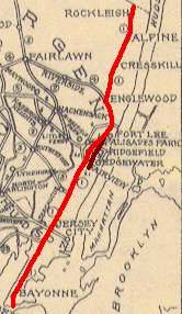
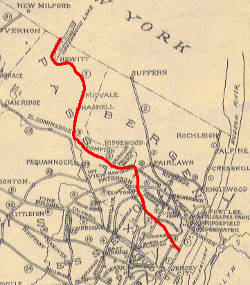
ROUTE No. 3. NEW YORK STATE LINE NEAR WESTERLY SIDE OF GREENWOOD LAKE TO SECAUCUS, via vicinity of Hewitt, Midvale, Haskell, Pompton, Haledon, Prospect Park, Hawthorne, Paterson, Westerly side of Passaic River to Ackerman Avenue in City of Clifton, Randolph and Parker Avenues to Passaic, to intersection of Monroe Street and Dundee Canal, covering Canal to Passaic River through Wallington via Maple Avenue, Paterson Plank Road through East Rutherford to Secaucus, terminating at Route No. 1. L. 1927, c. 319.
ROUTE NO. 3. Beginning in the vicinity of Hawthorne and Paterson, passing through Garfield, Wallington, East Rutherford and Secaucus, terminating on Route No. 1 in Secaucus. L. 1929, c. 126, p. 215, s. 3.
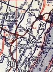
ROUTE NO. 3. Beginning in Secaucus and ending at the intersection of the Paterson-Plank Road in the borough of East Rutherford, and beginning again at Route No. 6 in the city of Paterson and ending at the intersection of Route S-4B in either Hawthorne or Glen Rock. Amended by L.1949, c. 292, p. 892, s. 1, eff. May 28, 1949.

3: From junction of Route U. S. 46 (former Route 6) Clifton, via former Route S-3 to junction with Route 20 (former Route 3) East Rutherford, via former Route 3 to Pleasant Avenue, Weehawken, and including section of the former Route 3 from Traffic Circle at Routes U. S. 1-9 to the intersection of the approach road to the Lincoln Tunnel. 1953 renumbering.
Left: NJ 3 in 1927.

Photos
End photos
History (Steve Anderson)

ends at Route 46 (US 46)
CliftonRoute 3
RutherfordRoute 3
East RutherfordRoute 3
SecaucusRoute 3
North BergenRoute 3
ends at Tonnelle Ave (US 1/US 9)


S3

S3 was given its number in the 1929 amendments, as a way for traffic on
3 to reach the realignment of 6 while bypassing Paterson to the south. S3 is now 3 west of 120 (since the GR), where 3 turned off of its current alignment. This existed on surface streets before the freeway was built in 1948-49. 1941 and 1946 maps show that Allwood Rd between Hepburn Rd and Bloomfield Ave was state maintained. A 1941 New York Times article states that this was to become part of S3 [NYT 8/10/1941, p. XX5]. The war got in the way of construction, and NJDOT decided after the war that it wanted more control of access, so a new alignment was built to the south. NJDOT later gave the road back to the county.
Some non-NJDOT maps from before the road was finished show possible temporary alignments. 1939: beginning at the southern section of 3 in the Meadowlands, west along Paterson Plank Road into Passaic, then south on River Rd and west on Van Houten Ave, south on Valley Rd, west on Great Notch Rd (later partly upgraded to 6), and west on Long Hill Rd and Main St to end at 23 at Singac. 1946: beginning at the southern section of 3 in the Meadowlands, west along Paterson Plank Road into Passaic, then south on River Rd and west on Van Houten Ave to 6. A 1939 NJDOT map agrees with the Van Houten routing but does not show west of there. Finally, a 1947 topo map shows S3 complete west of Passaic Ave, with a remnant S3 marker on Allwood Rd and one on Van Houten Ave. This suggests a temporary routing of S3 along Passaic Ave to connect the two.
The first section of S3 built was east of 17; that part opened in 1942. The part west of Passaic Ave opened by 1947. From there east to 21 opened in 1948, and the rest opened in 1949. The Passaic River bridge was opened on 9/12/1949, completing the route. In the 1953 renumbering, S3 was renumbered as part of 3. In 1960, the part in Clifton (west of 21) was widened from four to six lanes.

ROUTE NO. S-3. Beginning on Route No. 3 in East Rutherford, extending westerly and connecting with Route No. 2 in Rutherford, still in a westerly direction in the vicinity of Clifton and connecting with Route No. 6. L. 1929, c. 126, p. 215, s. 3. Amended by L.1949, c. 292, p. 892, s. 1, eff. May 28, 1949.

End photos

S3 Spur

S3 Spur was intended as a short spur off of
S3 along Clifton Ave., and may have been originally planned as part of 4. However, S3 moved onto the highway alignment before S3 Spur existed, so the Spur route never connected to its parent. It was under construction in 1953, so by the time it was open, it was renumbered to 161.

ROUTE NO. . Beginning at the intersection of VanHouten avenue and Clifton avenue in the city of Clifton and from thence to connect with Route S-3. L.1942, c. 77, p. 319, s. 1.
ROUTE NO. S-3, Spur. Providing a spur from Route No. S-3, in the vicinity of Broad street, thence in a northeasterly direction to the westerly end of Clifton avenue in the city of Clifton, county of Passaic. L.1948, c. 221, p. 1054, s. 1.

4

Parts of 4 started out as pre-1927 routes. 14 was defined in 1917 to run from Cape May to Egg Harbor City, 19 was defined in 1923 from Seaville to Absecon (but not built as 19), 4 was defined in 1916 for a road from Absecon to Rahway, and a spur of 7 was defined in 1925 from Lakewood to Freehold. In 1927, 4 was defined along the southern half of 14 (south of Seaville), all of 19, 4 from Absecon to Lakewood, the spur of 7 from Lakewood to Freehold, a new route from Freehold to South Amboy, 4 from South Amboy to Rahway, and a new route from Rahway north to Paterson and east to the planned George Washington Bridge. The rest of 14 (north of Seaville) became
50, and the rest of pre-1927 4 became 35 and 4N.
Here are the dates when the original route from Cape May to Rahway was built or taken over by the state:

sectionlocationdatewhat it was previously
(14) 1/takeoverCape May to Rio Grande?3/20/1919, 1920
(14) 2Rio Grande? to Locust Ln1919
(14) 4Locust Ln to Cape May Court House1920
(14) 5Cape May Court House to Swainton1922
(14) 8Swainton to Seaville1923
takeoverSeaville to Beesley's Point Bridge11/17/1931
Beesley's Point Bridge1928
takeoverBeesley's Point Bridge to Shore Rd, Absecon6/24/1930
8/takeoverAbsecon to Smithville5/1/1920
9/takeoverSmithville to Mullica River12/7/1921
31/takeoverMullica River to Tuckerton south line5/1/1920
18in Tuckerton5/1/1920
30/takeoverTuckerton north line to south of Barnegat5/1/1920
17in Barnegat5/1/1920
28/28A/takeovernorth of Barnegat to Beach Blvd, Lacey5/1/1920
27/takeoverBeach Blvd, Lacey to Cedar Creek5/1/1920
26/takeoverCedar Creek to Toms River?5/1/1920
23/takeoverToms River? to Cox Cro Rd, Dover5/1/1920
24/takeoverCox Cro Rd, Dover to Prospect St, Lakewood5/1/1920
15/takeoverProspect St, Lakewood to 885/1/1920
(7) 888 to Aldrich Rd, Howell1927
(7) 9Aldrich Rd, Howell to Elton-Adelphia Rd, Freehold1927
takeoverElton-Adelphia Rd, Freehold to Freehold?1928? 7/2/1935?CR 23
takeover34 to South Amboy7/2/1935CR 28, CR 65
dates for section that's now 34 are unknown
134 to South Amboy1929
South Amboy to Perth Amboy bridge7/1910built for streetcars
32Perth Amboy to Rahway9/1/1919

The other section of 4 to be built was from Paterson east to the George Washington Bridge. Here are dates for that section:

sectionlocationdatewhat it was previously
7Passaic River bridge1931Broadway
5Passaic River to 2081930Broadway
4208 to 171934
417 to Hackensack River1932new
3Hackensack River to Fort Lee1932new
6in Fort Lee1933new
George Washington Bridge10/25/1931new

Here are the dates for the bypasses that were built:

sectionlocationdatewhat it was previouslywhat the old road became
(GSP) 10Mullica River crossing8/28/1954new167
(4 Parkway) 22Toms River bypass1952newstayed as 4
3779 to Freehold Circle19384A
36Freehold Circle to Freehold-Englishtown Rd19364A
40Freehold-Englishtown Rd to Gordons Corner19394A
41Gordons Corner to 1819414A
418 to Ticetown Rd19414A
42ATicetown Rd to 3419424A
11/11A/11BSouth Amboy bypass1937
33/33ASouth Amboy to Amboy Ave, Woodbridge1926

The original route of pre-1927 4 through the Amboys came in on Pine Ave, turned right on Bordentown Ave, left on Stevens Ave, right on Main St (avoiding the "hole in the wall" on Stevens Ave), and then right onto the bridge to Perth Amboy (across from Scott Ave). The route through Perth Amboy was never state-maintained, but it was probably marked. Coming off the bridge onto Sheridan St, there are at least two routes indicated by maps: right on Market St, left on Prospect St, left on New Brunswick Ave, and right on Amboy Ave; and right on Smith St, left on State St, left on a road in the path of current 440, and right on Amboy Ave. State maintenance began at the Perth Amboy-Woodbridge line, and the Perth Amboy bypass (Convery Blvd) joins in soon after. This bypass was built in 1926, along with the new bridge over the Raritan River, with its south end at the north end of Main St in South Amboy, where the old bridge began.
In South Amboy, pre-1927 4 south of Main St became part of 35. 4 continued south on Main St out of South Amboy, but that was not built right away (as per the list above). The original routing of 4 appears to have temporarily followed 35 south to Keyport and then CR 516, before resuming on what's now 79. On 6/24/1930, when the part of 4 north into Absecon was taken over, downtown Absecon was bypassed. Old 4 north from downtown was renumbered as S4. When the cutoff from Freehold to Cheesequake was finished in 1942, 4 was rerouted onto it, and the old route became 4A.
Before the GR, 4 was proposed to extend south from its current west end, to connect to southern 4. A bit of this was signed along 3 (now part of 20) south to the end according to a 1936 Passaic County map. Two topo maps show 4 extending west on Broadway to downtown Paterson, which may have been signed by the city for continuity, and do not show 4 along 3. Another source has 4 continuing southwest from 3 along 6, Lexington Ave, and Clifton Ave, ending at Van Houten Ave. This may have been an early routing or apocryphal. 4 Parkway was a plan to bypass the south section of 4 and connect it to the northern section; this soon became the Garden State Parkway in the GR, after only a couple of sections were built.
In the 1953 renumbering, all of 4 south of the split with 35 in South Amboy became part of US 9, except the very southern part became 109 (which both 4 and US 9 used previously). North of the split, 35 was moved onto former 4 to Rahway, trading places with US 9. The northern part of 4, from Paterson east to the George Washington Bridge, remains 4 to this day (with the exception of the bridge itself). The section of 4 from Rahway to Paterson was never built. The original 1927 plan would have taken it south from Paterson on 3, west through Clifton on Piaget Ave, and south on Broad St into Essex County. The 1929 revisions included a bypass in Clifton around the eastern half of Piaget Ave. This was also part of 6, which continued west where 4 would turn south on Broad St. A 1934 map shows 4 going south past Piaget Ave to Clifton Ave, and then southwest on Clifton Ave to Van Houten Ave. It's possible that NJDOT built S3 Spur as part of this route.

ROUTE No. 4. HUDSON RIVER BRIDGE PLAZA TO PERTH AMBOY AND CAPE MAY, via Bridge Plaza, Riverside, Fairlawn, Paterson, Clifton, Route No. 3 to Randolph Avenue, Lexington Avenue, Piaget Avenue, Bloomfield Road and Broad Street, Bloomfield, East Orange, Irvington, Roselle, Route No. 27 in Linden, Rahway, Woodbridge, Perth Amboy, South Amboy, Main Street and extension to Rose's Corner, Cheesequake to point near White Brown's Corner, to Middlesex Road, Matawan, thence via Middlesex Road to Main St, Matawan, thence via Freehold, Lakewood, Toms River, Tuckerton, Absecon, via New Road to Somer's Point, Beasley's Point to Cape May. L. 1927, c. 319.
ROUTE NO. 4. Hudson river bridge plaza to Perth Amboy and Cape May. Beginning at the Hudson river bridge plaza and extending to Cape May City, via Riverside, Fairlawn, Paterson, Clifton, Bloomfield road, and Broad street via Bloomfield, East Orange, Irvington, Roselle, to Route No. 27 in Linden, Rahway, Woodbridge, Perth Amboy, South Amboy, via Main street and its extensions to Rose's Corner, Cheesquake, to a point at or near White Brown's Corner, thence to Middlesex road in the borough of Matawan, thence via Middlesex road to Main street, Matawan, thence via Freehold, Lakewood, Toms River, Tuckerton, Absecon, thence by New road to Somers' Point, Beesley's Point to Cape May. L. 1929, c. 126, p. 215, s. 4.
ROUTE NO. . Beginning at a point in State Highway Route No. 4 in Somers Point, Atlantic county, New Jersey, where the same terminates at or near the Great Egg Harbor bay and river, thence across the Great Egg Harbor bay and river along the route of the presently constructed roads and bridges connecting Cape May and Atlantic counties, to and thence connecting with State Highway Route No. 4 at Beasleys Point, Upper township, Cape May county. L.1942, c. 64, p. 304, s. 1.
4: From junction of Route 20 (former Route 3) Paterson, via former Route 4 to George Washington Bridge Plaza. 1953 renumbering

Photos
End photos
History of current 4 (Steve Anderson)

ends at McLean Blvd (20)
PatersonBroadway
Elmwood ParkBroadway
Fair LawnBroadway, Route 4
ParamusRoute 4
River EdgeRoute 4
HackensackRoute 4
TeaneckRoute 4
Englewood CityRoute 4
Fort LeeRoute 4
ends at I-95/Route 46/Fletcher Ave (I-95/US 1/US 9/US 9W/US 46)


4A

In 1942, when a bypass for
4 (US 9) between Freehold and Cheesequake was completed, 4A got the old routing via Matawan. This became 79 and the northern part of 34 in the GR.

End photos

4N

4N was given to part of what was 4 before the First Renumbering in 1927 (old 4 on both sides of 4N became
35, as did a bypass to the 4N portion). In the GR, 4N became 71.

ROUTE No. 4--NORTH (1917). EATONTOWN TO BELMAR, via Long Branch, Asbury Park and Bradley Beach.

4 Parkway

In 1946, the legislature authorized what NJDOT numbered as 4 Parkway, a car-only high-speed road not only filling the gap on
4 from Paterson to Rahway, but continuing south to Cape May. Its north end would be at 6 in Clifton, right around Broad St. It would also have a spur from Woodbridge to Trenton, known as the Cross-State Extension. Part of this road was planned as 4-Freeway, maybe the spur. The first section of 4-Parkway to open was from 27 at Menlo Park north to Central Ave in Clark Township. This road was opened on 7/28/1950 [NYT 7/29/1950, p.31]. Soon, the road was open from 35 (now US 9) in Perth Amboy north to Centennial Ave in Cranford, with the last section, from 35 to 27, opening on 11/1/1950. [NYT 11/2/1950, p.35]
The original plan for 4 Parkway would have taken it through the center of Monmouth County parallel to 4. The Monmouth Parkway was planned to serve the shore, paralleling 35 from near Point Pleasant north to 4 Parkway at South Amboy [NYT 3/18/1951, p.X15]. At some point, the planned 4 Parkway was rerouted to absorb the planned Monmouth Parkway. On 4/14/1952, the New Jersey Highway Authority was created to build 4 Parkway, since the state was running out of funds. The state-funded sections (exits 9-12, 80-83, and 127-140) would remain free, but the rest would be built as a toll road. Probably at this time it was extended north to 17 in Paramus. On 9/22/1952 the State Department of Law ruled that the New Jersey Highway Authority had the right to extend the parkway north to the New York state line from Paramus, but not charge tolls on it, based on the law that created the authority, which didn't limit construction of feeder roads. Obviously, at some later point a law was passed allowing tolls on the northern extension.

In the 1953 renumbering, 4 Parkway was numbered 444, and renamed the Garden State Parkway.
Here's a table of when each section of the Parkway opened:

sectionlocation (mileposts/exits)date
0-6after 9/19/1954
6-99/4/1954
9-12by 1952
12-2010/6/1954
20-27after 9/19/1954
27-295/26/1956
29?-36by 9/19/1954
36-508/11/1954
(GSP) 1050-528/28/1954
52-638/5/1954
63-807/15/1954
(4 PKY) 2280-831952
83-987/30/1954
(GSP) 798-105by 8/4/1954
(GSP) 7105-124? northbound8/7/1954
(GSP) 7124?-127 northbound7/30/1954
(GSP) 7105-127 southbound8/4/1954
(GSP) 6127-13111/1/1950
(GSP) 6131-1357/28/1950
(GSP) 6135-136~9/1950
(GSP) 5136-1407/16/1953
(GSP) 4140-1421/12/1954
(GSP) 4142-143
143-14511/26/1954 (planned)
145-1461/4/1955 (immediately closed by East Orange until extended to 148)
146-148 northbound1/7/1955 (planned)
146-148 southbound1/6/1955
148-1531/19/1955
153-1551/4/1955
155-157?1/19/1955
157-1637/1/1955
163-1727/3/1957
172-end8/30/1957

ROUTE NO. . Beginning at Route No. 6 at Clifton and running in a general southerly direction via Essex county, Union township, Cranford, Clark township and Woodbridge township to Cape May; with a branch from Woodbridge township to Trenton. L.1946, c. 117, p. 548, s. 1.

History of Garden State Parkway (Steve Anderson).

For more on 4 Parkway, see the Garden State Parkway.

S4

One section of S4 was legally defined in 1927 as the New Jersey approach to the Outerbridge Crossing. It was extended west to
35 (now US 9) in 1939 when that road was opened as a bypass to 4, and extended slightly further to the new 4 Parkway in 1951. Here's a table of when each section was built or taken over by the state:

sectionlocationdatewhat it was previously
GSP to US 91951Old Post Road
US 9 to 351939
135 to Outerbridge Crossing1928
Outerbridge Crossing6-29-1928new

S4 was renumbered 440 in the 1953 renumbering, to match NY 440. The road was upgraded to a freeway east of 35 and bypassed west of 35 in 1974, joining to an already-built section of freeway built in 1969. 440 was moved to the freeway and the old road (only west of 35) was renumbered to 184.

The other S4 was formed on 6/24/1930, when the bypass of Absecon on 4 was taken over by the state. The old alignment of 4 north from downtown became S4. In the 1953 renumbering, it became unnumbered, and was soon numbered 157.

ROUTE No. S-4. PROPOSED STATEN ISLAND BRIDGE PLAZA AT PERTH AMBOY TO ROUTE No. 4. L. 1927, c. 319.
ROUTE NO. S-4. Extending from the proposed plaza of the Staten Island bridge at Perth Amboy to Route No. 4. L. 1929, c. 126, p. 215, s. 4.

End photos

S4A

S4A was a proposed cutoff from Atlantic City through the swamps to Tuckerton. Originally only the part in Ocean County would be built by the state, with the rest built by Atlantic County. Atlantic County agreed that they would complete the extension, so the state started building the route in 1930 [NYT 6/22/1930], but after half a million dollars decided that it wasn't a priority to keep fighting the elements to construct a road that would keep getting battered by storms [Camden Post-Courier, 5/22/1934]. Asbury Park Press [1/3/1935] noted that the Federal government refused to allow their road work funds to be used for this project. The part from Brigantine to just north of the county line was never built, and the Ocean County portion was given to the county before 1941 as Great Bay Blvd. By 1945, what had been built from Atlantic City to Brigantine became
S56, and then became 87 in the 1953 renumbering.

Photos of Great Bay Blvd.
End photos

ROUTE No. S-4-A. EXTENDING FROM ROUTE NO. 4 NEAR TUCKERTON TO LITTLE BEACH. L. 1927, s. 319.
ROUTE NO. S-4-A. Extending from Route No. 4 at or near Tuckerton and extending to a point on Little Beach; provided, however, the county of Atlantic shall first agree to construct a suitable continuation of said road from Little Beach to the city of Atlantic City. L. 1929, c. 126, p. 215, s. 4.
ROUTE NO. S-4-A, Extension. Beginning at the southerly terminus of Route S4A on Little Beach and from thence to the city of Brigantine. L.1938, c. 341, p. 852, s. 1.

S4B

In the 1929 revisions, S4B was created as a spur northwest from
4 east of Paterson. From north of Paterson to the New York state line, it took over what had been assigned to 3 in the 1927 renumbering. A section of CR 511 near the NY state line is marked as S4B on a 1934 map; this was part of the original plan, which was never completed. The 1938 (and still 1949) Morris County map shows S4B extending just north of Ramapo Lake, probably as a "Jersey freeway" with some driveways similar to the rest of S4B. Skyline Drive now takes over the function of that proposed leg. S4B was renumbered to 208 in the 1953 renumbering to match NY 208, which was planned to extend south to meet it at the state line in a never-built mountain freeway following the same proposed S4B alignment. Here is a table of when each part was built:

sectionlocationdate
1A4 to Maple Ave1949
(208) 1Maple Ave to Colonial Rd1959
(208) 2BColonial Rd to Oakland Ave1962

Most of section 2B was rebuilt and used as part of I-287 in 8/1991.

ROUTE NO. S-4-B. Beginning on Route No. 4 in the borough of Fairlawn, extending northwesterly in the vicinity of Paterson, Hawthorne, Wyckoff, Franklin Lakes, Ringwood, West Milford and terminating at the New York state line. L. 1929, c. 126, p. 215, s. 4.

S4C

S4C includes what is now
162, as well as north and south extensions. It is unclear whether S4C was meant to encompass the current county route, or whether it was to have been built on a new alignment. If the former is true, it is then also unclear whether the route was ever taken over before the new bridge (162) was built in 1969.

ROUTE NO. S-4-C. Extending from Route 4 at Bennett Station, via Broadway in West Cape May, to Sunset boulevard, to the Delaware bay.

S4D

S4D was a proposed road north of Fort Lee. Though it was never built, the concept was preserved through a northerly extension of the NJ Turnpike numbered
55 pre-GR (though both are shown on a 1942 NJDOT map), and then 303 was reserved to match NY 303 in the GR.

ROUTE NO. S-4-d. The following route which shall be an extension of State Highway Route No. 4, shall commence at Route No. 4 in Teaneck township at Teaneck road and run generally in a northerly direction to a road known as Liberty road, in the township of Teaneck, being the location of a State Armory, township of Teaneck, Bergen county, New Jersey, and to be known as S-4-d. L.1938, c. 134, p. 286, s. 1. Amended by L.1941, c. 263, p. 696, s. 1.

Back to NJ State Routes main page
Back to the NJ Route Log main page
Back to NJ Roads
Back to Roads