New Jersey Roads - Essex County
Essex County


Passaic Avenue SB and NB, respectively, in Roseland at Harrison Avenue (SB, straight points to NJ 10, which is reachable via Eisenhower Parkway). These LGS's are all between about 20 and 30 years old, and are gradually being replaced by newer and often uglier manifestations.

This is now a LEFT TURN SIGNAL sign for NB Passaic Avenue in West Caldwell, but from the SB side, it clearly had a previous life, and one very incompatible with its current function.
 Harrison Ave. at Orton Rd. in West Caldwell: old and unusual town-name embossed sign.


Chestnut Lane and Maple Lane in Essex Fells.


The entirety of Glen Ridge captured in one photograph (split into two for this page). First, the traditional embossed street signage, and then one of the traditional gas-lit lampposts which adorn every street in the town, keeping the 1800's alive at least in one secluded community.


Caldwell has some lamps of its own. They look similar to Glen Ridge's. Hmm.


While we're in Caldwell, enjoy this stone arch I found carrying Westbrook Dr. over Pine Brook Creek.


A couple of Maplewood signs at the same street corner. The first points down Valley Rd. from Millburn Ave. WB and the second points down Millburn Ave. from Valley Rd. NB. Yep, neither street on the signs is present at the intersection, and vice versa.

Just past High St. in West Orange, Washington Ave. (CR 671) comes to High St. in Orange (CR 638), where this original county sign directs EB traffic to the right. Other little white signs I had on this page were at Central Ave. or Lyons Ave., and are now on the CR 508 or CR 602 pages (linked below).

Washington St. SB approaching Park Ave. in East Orange.


Again, Washington St. SB at Park Ave. Click on either half of the photo to see the respective signal LGS (little green sign).


I question whether you really want to send trucks toward a playground. The first sign is on Glenwood Ave. NB near Dodd St. and the second sign is upon turning east on Dodd St., so perhaps the truck route going straight was to avoid the school crosing to the right. Still not the best juxtaposition of signs.

This is in front of a school in Irvington. Not even a high school, so probably there was a problem with people coming by and playing loud music that excited kids and thus annoyed teachers.


A commercially depressed city often leads to the survival of old signs. These are facing north and south along Stuyvesant Ave., CR 619. The Dairy Queen appears to have gone off brand but won't sacrifice the old neon sign, which I mostly applaud but for deceptive business practices.
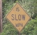
Throwing in an embossed Irvington speed limit sign. I think the police have more to worry about than controlling speed limits in troubled Irvington.


Sanford Ave., not Sandford Ave., SB from Newark (Vailsburg) into Irvington. This is CR 605, so blame the county for getting the street name wrong and the county shield ugly. The cities, I'm sure, know their own roads.
 CR 647, Union Ave., coming south out of Nutley.


Mill St. (CR 672) WB at the other end of Union Ave., just on the Belleville side of the Newark border.
CR 602, Lyons Ave.
CR 608, Hobart Gap Rd.
CR 609, Eisenhower Parkway
CR 611, Eagle Rock Ave.
CR 634, Laurel Ave.
CR 645, Franklin Ave. (Belleville/Nutley)
CR 646, Park Ave. (Nutley)
CR 649, JFK Parkway and S. Livingston Ave.
Bloomfield
Livingston
~ Locust Ave., Roseland-Livingston
Montclair
Newark
~ Broad St.
~ Clinton Ave.
~ Jackson St. Bridge
~ Newark Airport
~ Port Newark
~ Raymond Blvd.
CR 506, Bloomfield and Belleville Aves.
Spur CR 506, Bloomfield Ave.
CR 508
CR 509
CR 510, S. Orange Ave.
CR 527
To NJ 7
To NJ 10
To NJ 21
NJ 23
NJ 27
Former NJ 58
NJ 124
US 1-9
US 22
To US 46
I-78
I-95/NJ Turnpike
I-280
Garden State Parkway
I-280/Garden State Pkwy. interchange
Parkway frontage roads: Oraton Pkwy., Parkway Dr., JFK Dr.
Essex Co. route log
Back to New Jersey Roads
Back to Roads
