Massachusetts Roads - MA 2 - Boston
MA 2 in Boston
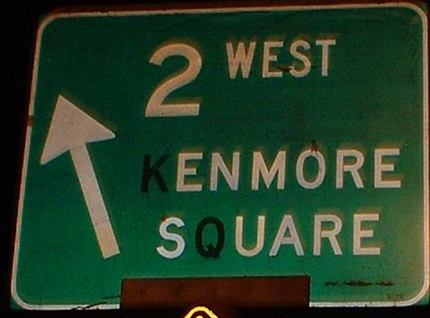
Rare unreplaced old Boston signs, on the MA 2 part of Beacon Street west of Kenmore Square. The intersection of Beacon and Park Drive (2 WB turns right off of Beacon WB, EB does opposite from Park SB) used to be a circle, and you can clearly see the circle in the form of four right-turn mini-ramps. Also, MA 2 is not signed between its two US 20 junctions, at the BU Bridge and at Kenmore Square, so heading WB you'd probably miss it entirely, and EB you'd have to know to make the left onto Park.
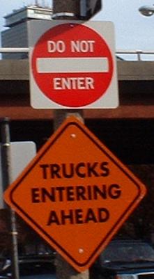
Oh, so we can't enter, but trucks can, huh? Huh?!
These signs face traffic that might want to turn from the Storrow Drive EB offramp into WB Comm. Ave. (i.e. MA 2) traffic at the Fenway interchange, instead of continuing across the wide divided avenue and then making their left. Not sure who's being warned about the trucks, but a similar wrong-way sign was found in the other direction in November 2002.
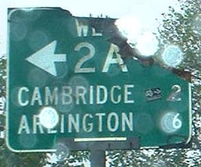
MA 2 WB, aka Commonwealth Avenue, approaching the beginning of MA 2A at Massachusetts Avenue. Or, in local dialect, Comm. Ave. at Mass. Ave. A couple of nice old wooden signs here, and it's the only overpass on Comm. Ave. (the through lanes run into the median and down under Mass. Ave., just like Mem(orial) Drive in Cambridge).
MA 2 EB at the same intersection, with a sign that should have been replaced a long time ago. Methinks Cookie Monster got a bit munchy during Passover and went for the nearest unleavened thing he could find.
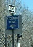
Eastbound at Berkeley St., in the middle of the ABC streets. MA 28 SB is Clarendon Street, and while Berkeley leads straight northward onto Storrow, MA 28 NB actually comes up Charles Street, turns on Beacon, and then on David G. Mugar Way to get to Storrow. (Mugar Way kinda takes over a small piece of Storrow Drive, but no one really knows it.)
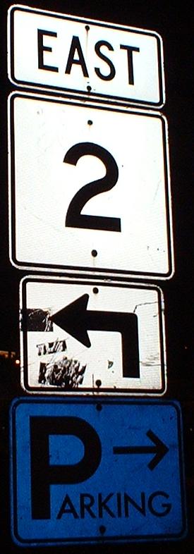
Near the eastern end of MA 2. Note the blue parking sign; most are green. The actual end of MA 2 is ambiguous. Following 2 EB, you come to the end of Commonwealth Avenue (Comm. Ave.) at Arlington St., and are forced right. You would then see the above sign and turn left, heading eastward again. The next step is to make a left at the far end of the Public Garden onto Charles Street, which is also MA 28 NB. (Charles Street used to be one-way NB directly into Hamilton Coolidge Square, but was turned back around SB through the tony shops north of the Garden - see the 28 link for more details.) By the time MA 2 makes a left onto Beacon Street, it has become westbound. To complete the loop, WB 2 traffic turns left onto Arlington St. at the western edge of the Garden, and makes a right onto Comm. Ave.
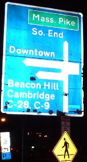
Just before the blue parking sign on Arlington St., and thus slightly cheating in the order on this page, this sign dates from the 1960's, and as you can see from the second picture, is made from two wooden boards nailed together. It shows C-9 and C-28, back when Boston had city routes corresponding to the same-numbered state routes (C-9 used to multiplex with C-1 down Beacon Street). It was done in a very European style, along with some other signs dating from a similar time in the Boston area, and thus it has a blue background - think of it as a citywide experiment?
Continue west on MA 2 over the BU Bridge
Back to MA 2 main page
Into Boston
Onto Massachusetts Avenue as MA 2A and as plain Mass. Ave.
To Storrow Drive
To the Mass. Pike, I-90
Back to Massachusetts Roads
Back to Roads