Vermont Roads - I-91
I-91

At the bottom of the SB Exit 2 ramp. I know we're in Brattleboro, but these are state-maintained highways and should not be circles (at least the 9's shouldn't).
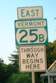
Courtesy Doug Kerr, VT 25 at I-91 Exit 16. Or is it I-89? Or...


Two shots from the 3-Y end of I-93 at I-91's Exit 19, first from Doug Kerr and second from Lou Corsaro; I-93 just barely crosses from NH to end here. Notice how VTAOT (Agency Of Transportation) underlines cardinal directions here.


College Rd. EB underneath I-91 SB and NB near Lyndonville.


Blue arrow doesn't belong with these circle shields, at the bottom of the NB Exit 1 ramp. VT 119 is very short, turning quickly into NH 119.
All remaining northbound photos are courtesy Adam Prince (such as the one above) or Dan Vincent (such as the one below).

The old New England font used in Maine and Massachusetts until the nation's bicentennial makes its way over to a Vermont milemarker.

Also from Dan, there should be an I-91 shield on the pull-through BGS.


Somewhat old Big Green Signs, northbound, matching others at that interchange - both in the 1/3 mile given as an advance distance, and in the cloverleaf diagrammatic (well, it's almost a complete cloverleaf). These are the final Dan Vincent signs; the remainder are Adam's.


Behind these shields you can see the original outlines of an older US 5 shield and a square VT 10A shield.


All of the signs are old, but one hasn't been retrofitted with an exit tab yet. That's it for Adam's photos.


By definition, the first southbound photo on I-91.


Under Coventry Station Rd. in Coventry.


These old distance signs, even featuring mile-km conversions, straddle Exit 18. The first photo is courtesy Doug Kerr and the others are courtesy Lou Corsaro.


Still from Lou.


Y'know, when you're not the one who took the photos, it takes effort to figure out where you are when there are no exit tabs. These are Exits 16 (VT 25, from Doug) and 15 (US 5 alone, from Lou). The distance sign in the middle is also from Lou.


As you can see, US 5 and I-91 are like wine and cheese. Also as you can see, sometimes VT forgets its exit tabs (same problem on I-89). All of these are Lou's photos until the last (nighttime) one, which I kept from Doug to prove these are all button copy. I don't know why the NH was pried off of that I-89 sign, or why the 89 is off center.

Courtesy Michael Summa, this photo was taken in 1980. The sign is a contemporary of many others on this page, but was quite a bit newer in this photo (and still looks old). The non-outlined Interstate shield (they are usually rimmed in white) is still around in many places today, and if you look up at the last one of my (daytime) photos in the run above, you'll see that the old-style Exit 11 tab with the stick 1's is also still around.

Another advance for I-89, from Lou; it doesn't get an exit number because it's an Interstate.

Throwing in my own scenery photo past White River Junction.
Into Massachusetts on I-91
Into New Hampshire on I-93
Exit 2 to VT 9
Exit 2 to VT 30
Any exit to US 5
Exit 7 to VT 11
Exit 7 to VT 106
Exit 10 to I-89
Exit 13 to NH 10A
Exit 14 to VT 113
Exit 17 to US 302
Exit 23 to VT 114
Back to Vermont Roads
Back to Roads