New Jersey Roads - NJ 15

First photo above is on Pequannock St. SB just south of US 46, courtesy HNTB Corporation - it's not NJ 15, just the way to get there from US 46 EB. Second photo is on NJ 15 SB where the freeway begins at NJ 181.

These are on NJ 15 SB approaching and then at US 46. This is one of those places where you can make a right turn to go from SB to EB. 15 crosses under 46 just west of the town of Dover, where the only ramp is WB-NB, then runs parallel to it a block south for awhile on Clinton Street. Finally giving that up, 15 SB curves to the north, where you see the first sign, makes a left turn on Bergen Street (after passing Warren, Sussex, Morris, and Essex - notice a pattern?), and ends at 46. Going straight brings you to I-80 at Exit 35, as you see by the second sign, just a mile east of 80's junction with 15 at Exit 34. In other words, by following NJ 15 SB you can make a complete loop. This will change shortly, as plans are in the works to bring NJ 15 to a proper grade intersection with US 46 where 46 currently has an overpass; the river/railroad/15 overpass is due to be rebuilt anyway. Clinton Avenue will then dead-end just before reaching 46, because there's not enough room to bring it up the hill to 46 (whereas 15 is coming down a hill the other direction, and thus can just be smoothed out to level). See the construction photos below. The first, embossed sign in this run dates from probably the 1940's, and is one of the last state-owned signs that hasn't been replaced by green guide signage.
NJ 15 NB starting life on Bergen Street. I don't know if/how mileposts will be adjusted post-construction.

The southernmost NJ 15 shield, and only the second indication that you're on a state-maintained road (well, that and the fresh new NJDOT-installed pavement). I believe Clinton Street will revert to Dover maintenance, because I have seen no plans to designate a new 1xx route over this piece of NJ 15 to be disconnected.

SB at Morris St. and an old hydrant at Sussex St. Although the "N" was greened out of the CR 643 shield, the county route does extend north up to US 46, except it's one-way SB so it would be wise to avoid any suggestion that traffic could turn.

Heading north underneath US 46 and swiveling around to facing south. This is one of two overpasses that will be replaced. NJ 15 will cross the railroad on a new bridge and intersect US 46 just west of these photos.

NJ 15 NB alongside the reconstruction of the US 46 WB ramp, then up onto the ramp and heading north onto 15. The reason these photos are here instead of on the US 46 page is that they are showing the temporary path of NJ 15 as construction progresses. By pushing the pavement out to the edge of existing NJ 15, NJDOT can barely squeeze two lanes on top of the embankment for both directions of traffic. As soon as this opens, NJ 15 will never again pass beneath US 46.

Back south down the ramp (future temporary NJ 15 SB) to a strange pole at US 46. These are apparently the permanent utility poles, although still set temporarily in concrete-filled holes until construction finishes. I've never seen a rectangular pole and I never hope to again.

Big shield, little shield, lots of shields, NB.

Looking north and south at a small piece of Union Tpk., original NJ 15, just north of I-80.

NB up a longer alignment of Union Tpk. next to the SB side of NJ 15, dead-ending in the last photo.

An old sign at a building driveway that has been closed in favor of one directly on (modern-day) NJ 15, and Union Tpk. SB merging back into NJ 15 SB.

The first is Edison Rd. WB at NJ 15 SB, and the rest are proceeding southward on that highway toward I-80. The second sign hints at a possible KENVILLE mispelling. Through this area immediately north of I-80, NJ 15 NB is the old highway, hemmed in by stores, while the SB lanes are a little less claustrophobic.

If you're wondering why the utterly forgettable town of Berkshire Valley won't allow its part of NJ 15 to be upgraded to freeway, maybe your answer lies in the fact that out of just three interchanges on the actual freeway segment, one took until 2004 to finally be complete (the CR 517 Sparta Bypass was held up east of Sparta), and the one at Blue Heron Road still isn't complete. The sad thing is, the road once did go to Blue Heron Lake, but was chopped off just east of NJ 15. As a result, what was graded as a cloverleaf has turned into a half-diamond/half-folded diamond, going so far as to stick a Park and Ride over the NB-EB right of way. The photo here is where the WB offramp would have merged into the NB lanes. Rather than reconfigure the interchange to allow a smooth trumpet (i.e. have all NB-on traffic come on the outside of the NB-WB loop), all traffic instead uses the EB-NB loop, creating an unnecessary weave on the NB side of 15. You can see the rest of the interchange on the NJ 181 page (big link at bottom).

NB at the next exit, CR 517, which as I mentioned was only recently built beyond NJ 15 to the east. There is a nasty bit of railroad that complicated things, requiring some odd angles and steep hills immediately to the east at Station Road. Main St., old CR 517, is just to the south, and Station Rd. turns into CR 620 there (although it's possible, based on signage, that 620 is extended to the new 517).

SB at the same spot.
NJ 181, former NJ 15
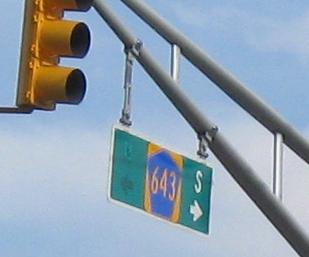
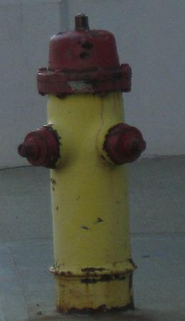
Onto US 46
To I-80
Onto CR 517
NJ 15 ends at US 206
NJ 15 on Steve Anderson's nycroads.com
Back to NJ Roads
Back to Roads