México Roads - Cancún
Cancún
All photos courtesy Steven Demetropoulos.


Along Highway 307 southbound - it starts as a left fork from Highway 180 eastbound, heading northeast (i.e. the wrong direction), and then curves around south - 180 and 307 end at each other. I'm not sure if México signs highways by direction like the U.S. or by destination like Italy. In the first photo, where the km/h is useful to tourists but otherwise unnecessary, the sign in back says no littering in the right of way (derecho literally means right in all of its forms - as in your right hand, your right to free speech, right whale, etc.). The last sign is for a U-turn; México appears to construct its BGS's like American LGS's.


Desviación, if you couldn't tell, means detour. Signs are similar to the American and/or Canadian standards. The merge sign uses an arrow similar to the Ontario lane arrow, but is uniquely Mexican on a merge sign. This highway may not be high speed, but it has multiple lanes and grade separation... so it's probably a speed trap for tourists. that's why you should respect (i.e. obey) the speed limit.

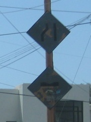
On the Yucatán Peninsula, the women are famous for being so well endowed... These are somewhat dangerous looking speed humps taken somewhere near Playa del Carmen on Highway 307, facing northwest (Xel-Ha and Xcaret are toward Tulum). Thank the Mayans for the name Xcaret, and ask them how to pronounce it.

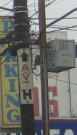
Now in Playa del Carmen, on the Riviera Maya. The signal sign has a tail on the bottom, which has no analogue in the signal itself. The right turn in the second photo is to be taken with care; note that a red circle in México has the same meaning as a green circle in most countries (they've hybridized the European circle with the American slash). And the E? Obviously it means no parking. Try Estacionar.
Back to México Roads
Back to Roads