Steve Alpert's Roads

Since I was 3 years old, I've been drawing highways on pieces of paper (and making interchanges out of clay) - my favorite is a bunch of my father's old business cards that I taped together and drew several multicolored cities on. (Yes, I ended that sentence with a preposition.) I also love reading maps, and going on new highways to new places. That's why I've been to all 46 states, 4 commonwealths, and 1 district of the United States. I've also seen 1 American territory, 7 Canadian provinces, and 3 European countries. I've taken road photos in many of those locations and put them up here, along with many people's generously submitted photos, for your enjoyment.

Counties I've visited (on Mob Rule) - you can click on top to see U.S. and Canada statistics, a U.S. graphic, or click on each state/province.

If you would like to use any photo on this website, you may provided I am the photographer, but please give credit, and if applicable, please link to my site or at least the page from which you took the image. [Note: This applies to any non-commercial use, including Wikipedia, so long as proper attribution is given.] If you would like to use any photo that was submitted, please ask and I will contact the relevant person, or notify me that you have contacted the person yourself.

Email me with photos, questions, comments, information, corrections. Inform me of a broken link or make a new friend.
An explanation of terminology and abbreviations on this website
Special features and external links
Most recent update
Also find me on Twitter @AlpsRoads!


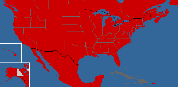
Below is a clickable map - the red states, provinces, etc. are places viewable on this website. If you're bad at geography, think Italy is swallowing the rest of Europe, don't know what that little thing is that I put next to Cuba, or can't seem to get your mouse onto Washington, DC, I'll be nice and provide the individual links for you at the bottom of the image.


Alabama Alaska Arizona Arkansas California
Colorado Connecticut Delaware Florida Georgia
Hawai`i Iowa Idaho Illinois Indiana
Kansas Kentucky Louisiana Maine Maryland
Massachusetts Michigan Minnesota Mississippi Missouri
Montana Nebraska Nevada New Hampshire New Jersey
New Mexico New York North Carolina North Dakota Ohio
Oklahoma Oregon Pennsylvania Rhode Island South Carolina
South Dakota Tennessee Texas Utah Vermont
Virginia Washington West Virginia Wisconsin Wyoming
District of ColumbiaPuerto Rico
Alberta British Columbia Manitoba New Brunswick Newfoundland
Nova Scotia Ontario Prince Edward Island Québec Saskatchewan
Czech Republic Israel Italy Jordan México
Norway Poland Sint MaartenSwedenSwitzerland


Special Links - My Site

Among many of the states on this site are hundreds of photos from the 1970's and 1980's, courtesy Michael Summa and Averill Hecht. Also see samples of Michael's sign collection as linked immediately below. Unlike my own sign collection, you won't see Michael Summa's personal signs on any other page on this site. Because they're too special to spread around like that.

My sign collection
Michael Summa's sign collection

Highways I've clinched

Original Interstate highway plans from 1957 and 1958

SPUI's New Jersey Highways at its new home

The Cape May-Lewes Ferry, US 9

New River Gorge (WV) Bridge Day, 10/17/09

Road meets:
Albany, 10/11/03
Elmira, NY, 9/30/06
Poughkeepsie, 4/14/07
Hartford, 4/26/08
New Brunswick, NJ, 9/14/08
Buffalo, 10/18/08
State College, PA, 4/18/09
Indianapolis, 7/10-11/09
Highland, NY, 10/3/09
Washington, DC, 11/21/09
Detroit, 1/2/10
Tulsa, 2/22/10
Baltimore, 4/17/10
Akron-Canton, 5/8/10
Southeast PA, 6/19/10
Providence, 8/7/10
South Jersey Invitational, 12/18/10
Columbus, 5/14/11
Montréal, 5/28/11
Morgantown, WV, 6/18/11
Wausau, 10/1/11
Bennington, VT, 11/12/11
Ottawa, 8/25/12

Alps' Non-Roads
Links - External

Keep in mind that these very informative links will not be found on the various state pages because they cover more than one state.

AARoads Forum for highway discussion - join today!

INTERNATIONAL
Mark Furqueron's Highway Page

NATIONAL
James Lin's Highway Route Markers
Route termini on State-ends.com
The Historical Marker Database
Historic Aerials (back to the 1930's)
Scott Steeves' and Cameron Bevers' CanHighways
AARoads - Interstate, US, and state routes
Robert Droz's US-Highways.com
US Highway Ends
Mark Roberts' US Highways Signs and Sights
Gribblenation
Marc Fannin's and Sandor Gulyas' Roadfan.com
Tom Valazak's Cross Country Roads
The Floodgap Roadgap
Eric Smith's Expressway Site
Rachel Aschmann's Traveling

REGIONAL
Adam Froehlig's Froggie's Place
H. B. Elkin's Millenium Highway
Scott Oglesby's (Kurumi's) Roads
Scott Kozel's Roads to the Future
Barry L. Camp's Roadpix
Dan Vincent's Roads and Highways of the Pioneer Valley
Gene Van's My Land of Misery
Bill Burmaster's Roads of the Mid-South & West
Jake Wimberley's Kennessippi Roads
Chris Geelhart's Northern Plains Highways
James Teresco's Travel and Other Pictures
Scott Steeves' Asphalt Planet (Ontario-centric)

Updated: 5/23/13
Click here for previous updates


Iowa
- 2 new photos
I-29 - 2 new photos
I-35 - New page, 10 new photos
I-235 - New page with 20 photos
I-74 - New page with 10 photos
I-80 - 7 new photos
I-280 - New page with 10 photos
I-380 - 11 new photos
I-480 - New page with 4 photos
I-680 - New page with 9 photos
US 218/IA 27 - Split from I-380, 2 new photos
New pages: US 6, Old US 6, White Pole Rd., US 20, US 52, US 61, IA 92, IA 136, IA 163, IA 192, IA 220, Delaware CR C64, Delaware CR D13, Dubuque CR D21, Madison CR G31, 5th St., Adair, Des Moines, Bob Kerrey Pedestrian Bridge, Marion County, Madison County, Misc. photos - Total of 297 new photos

Nebraska - 3 new photos
I-80 - New page, 5 new photos
I-680 - New page with 21 photos
US 6 - New page with 5 photos
NE 92 - New page, 7 new photos

Kansas
I-70
- 6 new photos
US 36 - Moved from Business US 36, 7 new photos
US 40 - 15 new photos
US 56 - 8 new photos
Misc. photos - 4 new photos
New US 66 pages: Baxter Springs, K-66, Galena - Total of 29 new photos
Other new pages: I-35, I-135, I-235, I-435, I-470, US 24, US 50, Old US 50, Emporia-Ottawa, US 59, US 69, US 77, K-18, K-92, K-96, K-114, K-131, K-140, K-181, K-191, K-221, Historic Trails Park - Total of 210 new photos

Missouri
Misc. photos
- 3 new photos
New US 66 pages: MO 66, Jasper County, Jasper SR HH, MO 96, Lawrence CR 2062, Paris Springs, MO 266, Springfield, Laclede County, Business Loop I-44, Waynesville-St. Robert, Pulaski SR Z, Teardrop Road, Former US 66/I-44, Arlington, Phelps County, Crawford SR ZZ, Franklin County/Business I-44 (Pacific), MO 100, Route 66 State Park, MO 366, MacArthur Bridge, Martin Luther King Bridge, McKinley Bridge - Total of 329 new photos
Other new pages: I-29, I-35, I-435, I-635, I-44, I-55, I-155, I-255, I-57, I-64, I-70, I-270, I-470, I-670, US 60, US 61, Old US 61, Pemiscot County, US 67, US 69, US 71, US 169, MO 9, MO 92, MO 152, MO 291, MO 364, MO 370, Eads Bridge - Total of 307 new photos

Oklahoma
I-44 mainline
- 5 new Tulsa photos
US 64 mainline - 28 new photos west of Tulsa
Original US 66 in Tulsa - 2 new photos
US 281 - 3 new photos
OK 11 - 14 new photos
OK 18 - 8 new photos
OK 51 - 3 new Cincinnati Ave. photos
OK 66 - 4 new photos
Misc. photos - 4 new photos
New US 66 pages: Southwest Blvd., Sapulpa-Tulsa, Ottawa County, US 69, Commerce, Alt. US 69 - Total of 56 new photos
Other new pages: Picher ghost town, US 60, Old US 64, Garfield County, US 77, US 412, OK 33, OK 45, OK 105, OK 123, OK 266, 96th St. Bridge, Tulsa - Total of 152 new photos
Below are three interchanges I've drawn, in order of complexity. The first, green one is a 10-way interchange (four through highways, two beginning there). The second (black, red, and blue) has 11 spokes coming out of the hub: five through highways and one starting in the interchange. Finally, the third, dark blue one has 6 through highways for a total of 12 spokes, taking up more than half of the 9" x 12" page. I have a 13-way interchange in development.


My maps also annex people's dinner settings.